Fichier:Qinghai lake.jpg

Fichier d’origine (640 × 640 pixels, taille du fichier : 138 kio, type MIME : image/jpeg)
| Ce fichier et sa description proviennent de Wikimedia Commons. | Accéder au fichier sur Commons |
Description
| Description |
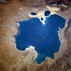
Deutsch: Qinghai-See, China - November 1994
English: Qinghai Lake, China - also, originally known as Koko Nor in Mongolian and Tso Ngonpo in Tibetan - November 1994
Español: Lago Qinghai, China - Noviembre 1994
中文:青海湖 |
|||||
| Date | Prise le 8 novembre 1994, 04:13:36 GMT | |||||
| Source |
https://eol.jsc.nasa.gov/sseop/EFS/photoinfo.pl?PHOTO=STS066-118-23 https://eol.jsc.nasa.gov/SearchPhotos/photo.pl?mission=STS066&roll=118&frame=23 |
|||||
| Auteur | NASA | |||||
| Autorisation (Réutilisation de ce fichier) |
|
|||||
| NASA information |
|

| Lieu de la prise de vue | | Voir cet endroit et d’autres images sur : OpenStreetMap |
|---|
Cette image ou vidéo a été cataloguée par l’un des centres de la National Aeronautics and Space Administration (NASA) des États-Unis sous Photo ID : STS066-118-23.Ce bandeau n’indique rien sur le statut de l’œuvre au regard du droit d'auteur. Un bandeau de droit d’auteur est requis. Voir Commons:À propos des licences pour plus d’informations. Autres langues :
|
Historique du fichier
Cliquer sur une date et heure pour voir le fichier tel qu'il était à ce moment-là.
| Date et heure | Vignette | Dimensions | Utilisateur | Commentaire | |
|---|---|---|---|---|---|
| actuel | 10 octobre 2005 à 17:02 | | 640 × 640 (138 kio) | Immanuel Giel | Qinghai Lake, China - November 1994 '''Source''': from the English Wikipedia<br> image description [http://eol.jsc.nasa.gov/sseop/EFS/photoinfo.pl?PHOTO=STS066-118-23 here] en:Qinghai Lake {{PD-USGov-NASA}} |
Utilisation du fichier
La page suivante utilise ce fichier :
Usage global du fichier
Les autres wikis suivants utilisent ce fichier :
- Utilisation sur ace.wikipedia.org
- Utilisation sur ar.wikipedia.org
- Utilisation sur ast.wikipedia.org
- Utilisation sur az.wikipedia.org
- Utilisation sur ba.wikipedia.org
- Utilisation sur be.wikipedia.org
- Utilisation sur bg.wikipedia.org
- Utilisation sur bn.wikipedia.org
- Utilisation sur bo.wikipedia.org
- Utilisation sur br.wikipedia.org
- Utilisation sur ca.wikipedia.org
- Utilisation sur cdo.wikipedia.org
- Utilisation sur ceb.wikipedia.org
- Utilisation sur cs.wikipedia.org
- Utilisation sur cv.wikipedia.org
- Utilisation sur da.wikipedia.org
- Utilisation sur de.wikipedia.org
- Utilisation sur el.wikipedia.org
- Utilisation sur en.wikipedia.org
- Utilisation sur en.wikivoyage.org
- Utilisation sur eo.wikipedia.org
Voir davantage sur l’utilisation globale de ce fichier.