Fichier:Moon crustal thickness map NASA-JPL.jpg

Taille de cet aperçu : 800 × 515 pixels. Autres résolutions : 320 × 206 pixels | 640 × 412 pixels | 1 024 × 659 pixels | 1 280 × 824 pixels | 2 120 × 1 364 pixels.
Fichier d’origine (2 120 × 1 364 pixels, taille du fichier : 1,79 Mio, type MIME : image/jpeg)
| Ce fichier et sa description proviennent de Wikimedia Commons. | Accéder au fichier sur Commons |
Description
| Description |
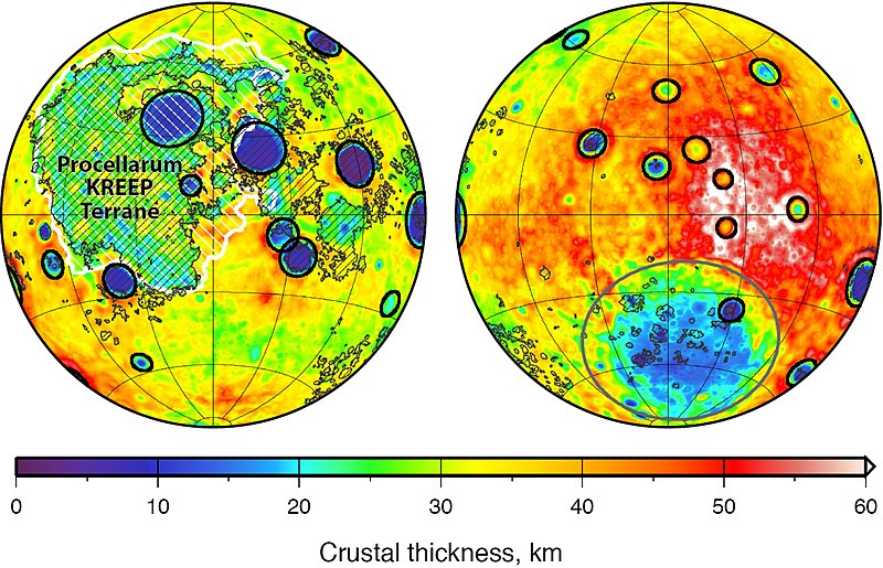
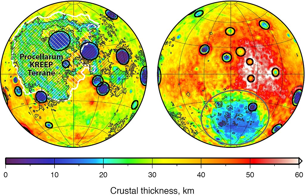
English: Global map of crustal thickness of the moon derived from gravity data obtained by NASA’s GRAIL spacecraft. The lunar near side is represented on the left hemisphere. The far side is represented in the right hemisphere.
In the left hemisphere, outlined in white, is the Procellarum KREEP Terrane, a large province on the near side of the moon which contains high abundances of potassium, rare earth elements and phosphorus [as well as Uranium and Thorium]. Excluding the Aitken basin at the south pole (the gray circle on the lower half of the far side hemisphere), there are 12 impact basins with crustal thinning that have diameters greater than 124 miles (200 kilometers) on each hemisphere. Those are marked with black circles. The image is presented in two hemispherical Lambert azimuthal equal-area projections centered over the near side (left), and far side (right) hemispheres. Deutsch: Karte der Krustendicke des Mondes, basierend auf Daten der GRAIL-Sonde der NASA. Die erdzugewandte Seite des Mondes ist links abgebildet, die erdabgewandte Seite ist rechts abgebildet. In der linken Teilabbildung weiß umrandet und schraffiert ist das Procellarum-KREEP-Terran, ein großer Bereich auf der erdzugewandten Seite des Mondes, der durch eine erhöhte Häufigkeit von Kalium, Seltenerdmemetallen und Phosphor [sowie Uran und Thorium] gekennzeichnet ist. Abgesehen vom Aitken-Becken in der Südpolarregion (markiert durch den grauen Kreis in der rechten Teilabbildung) gibt es in jeder der beiden Hemisphären 12 Einschlagsbecken mit ausgedünnter Kruste, die einen Durchmesser von mehr als 200 Kilometern (124 Meilen) aufweisen. Diese sind durch schwarze Kreise gekennzeichnet. Die Karte ist erstellt in hemisphärischer flächentreuer Lambert’scher Azimutalprojektion, zentriert auf die erdzugewandte (links) und erdabgewandte (rechts) Hemisphäre. |
| Date | (released) |
| Source |
|
| Auteur | NASA/JPL-Caltech/S. Miljkovic |
Cette image ou vidéo a été cataloguée par le Jet Propulsion Lab de la National Aeronautics and Space Administration (NASA) des États-Unis sous Photo ID : PIA17674.Ce bandeau n’indique rien sur le statut de l’œuvre au regard du droit d'auteur. Un bandeau de droit d’auteur est requis. Voir Commons:À propos des licences pour plus d’informations. Autres langues :
|
Conditions d’utilisation
| Ce fichier provient de la NASA. Sauf exception, les documents créés par la NASA ne sont pas soumis à copyright. Pour plus d'informations, voir la politique de copyright de la NASA. | ||
 |
Attention :
|
Historique du fichier
Cliquer sur une date et heure pour voir le fichier tel qu'il était à ce moment-là.
| Date et heure | Vignette | Dimensions | Utilisateur | Commentaire | |
|---|---|---|---|---|---|
| actuel | 7 janvier 2019 à 16:52 | | 2 120 × 1 364 (1,79 Mio) | Gretarsson | {{Information |description ={{en|1=Global map of crustal thickness of the moon derived from gravity data obtained by NASA’s GRAIL spacecraft. The lunar near side is represented on the left hemisphere. The far side is represented in the right hemisphere.<br/> In the left hemisphere, outlined in white, is the Procellarum KREEP Terrane, a large province on the near side of the moon which contains high abundances of potassium, rare earth elements and phosphorus. Excluding the Aitk... |
Utilisation du fichier
Les 2 pages suivantes utilisent ce fichier :
Usage global du fichier
Les autres wikis suivants utilisent ce fichier :
- Utilisation sur de.wikipedia.org
- Utilisation sur en.wikipedia.org