Fichier:AERIAL VIEW LOOKING NORTH. FRANKFORD CREEK IN FOREGROUND. - Frankford Arsenal, South of Tacony Street between Bridge Street and tracks of former Pennsylvania Railroad, HAER PA,51-PHILA,693-3.tif

Taille de cet aperçu JPG pour ce fichier TIF : 781 × 599 pixels. Autres résolutions : 313 × 240 pixels | 625 × 480 pixels | 1 001 × 768 pixels | 1 280 × 983 pixels | 2 560 × 1 965 pixels | 5 000 × 3 838 pixels.
Fichier d’origine (5 000 × 3 838 pixels, taille du fichier : 18,3 Mio, type MIME : image/tiff)
| Ce fichier et sa description proviennent de Wikimedia Commons. | Accéder au fichier sur Commons |
Description
| AERIAL VIEW LOOKING NORTH. FRANKFORD CREEK IN FOREGROUND. - Frankford Arsenal, South of Tacony Street between Bridge Street and tracks of former Pennsylvania Railroad, Philadelphia, Philadelphia County, PA | ||||
|---|---|---|---|---|
| Titre |
AERIAL VIEW LOOKING NORTH. FRANKFORD CREEK IN FOREGROUND. - Frankford Arsenal, South of Tacony Street between Bridge Street and tracks of former Pennsylvania Railroad, Philadelphia, Philadelphia County, PA |
|||
| Description |
Gorgas, Josiah; Laidley, T T, S; Benet, Stephen Vincent; Pitman, John; Dunn, Beverly; Campbell, Levin H; Edwin H. Fitler Company; U.S. Government; Fraser, John; John Milner, Associates, historian; Clement, Dan, historian; Boucher, Jack, photographer; O'Bannon, Patrick W, historian |
|||
| Lieu représenté | Pennsylvania; Philadelphia County; Philadelphia | |||
| Date | Documentation compiled after 1968 | |||
| Dimensions | 4 x 5 in. | |||
| Lieu actuel |
Library of Congress Prints and Photographs Division Washington, D.C. 20540 USA http://hdl.loc.gov/loc.pnp/pp.print |
|||
| Numéro d’inventaire |
HAER PA,51-PHILA,693-3 |
|||
| Attribution de l’acquisition |
|
|||
| Notes |
|
|||
| Source | https://www.loc.gov/pictures/item/pa1439.photos.140070p | |||
| Autorisation (Réutilisation de ce fichier) |
|
|||

| Position de l'objet | | Voir cet endroit et d’autres images sur : OpenStreetMap |
|---|
Historique du fichier
Cliquer sur une date et heure pour voir le fichier tel qu'il était à ce moment-là.
| Date et heure | Vignette | Dimensions | Utilisateur | Commentaire | |
|---|---|---|---|---|---|
| actuel | 30 juillet 2014 à 13:43 | 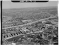 | 5 000 × 3 838 (18,3 Mio) | Fæ | GWToolset: Creating mediafile for Fæ. HABS 30 July 2014 (2901:3000) |
Utilisation du fichier
La page suivante utilise ce fichier :